
To More Inquiry

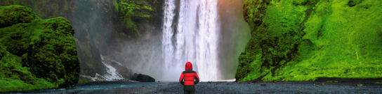
Grade:Difficult Location: Ladakh Altitude:6250 m Duration:12 Days Located in Hemis National Park, Kang Yatse II, at 6,250M, is the shorter of the two cousins with Kang Yatse I towering beside it at 6,400M. As one of the highest trekking peaks in the vast expanse of the arid terrain in Ladakh, Kang Yatse II makes itself seen on day 6 of our trek as we make our way to its base through Markha Valley. The peak is a thing of sheer beauty standing tall in the middle of this dry land of scree and loose rocks. Starting from the high mountain city of Leh, you are in the presence of beauty from the get-go. The drive up to Skiu, the confluence of the distinctly colored rivers - Zanskar and Indus, the occasional sighting of wildlife that’s endemic to the region, the excruciatingly dry yet gorgeous trek through Markha Valley to finally reach the slopes of this much sought after peak which is 6,250M of beauty that’s hard to ignore once you lay your eyes on it. Passing through quaint settlements scattered across this arid landscape give you a glimpse into the local culture and livelihood of the region. Religious shrines, mani walls, stupas and other signs of the faith of the land and its people, pepper the landscape. The prayer flags add to the color palette of this otherwise monochromatic backdrop. They also lend a sense of peace to the continuously thinning air as we go up towards the higher reaches of this exquisite peak. This mud civilization is not short of old monasteries, ruined forts and abandoned structures which camouflage themselves amongst the peculiar geographical formations in the region adding to the mystery of the place. While most of the trek is long distances on a harsh terrain, the toughest day of the entire trek remains summit day when we gain an altitude of 1,200M in a single go. The climb back down through the high altitude pass – Kongmaru La which lies at an elevation of 5,236M is yet another feature of the trek which single-handedly holds the capacity to push it straight to the top of your must-do list. The climb up to Kongmaru La pass is a few patches of steep incline between long distances of flat land rich in pikus and marmots and provides for magnificent views of Kang Yatse I, Kang Yatse II and Dzo Jongo. Adorned with prayer flags, the wind on the pass is fierce. The descent from the pass goes through deep gorges and water crossings with the valley appearing and disappearing on every turn. The terrain is interesting in its colours with rocks spread across the colour palette, geological formations with massive walls standing vertically on either side of you and the gush of water filling up these narrow passageways to the strangest and most interesting fauna you will ever see. Kang Yatse is a trekking peak meaning it does not require the use of technical equipment and technical skills. But, given the level of endurance required and its high altitude, this trek is for experienced climbers only. June to September are the best months to attempt this peak.
The trek starts from Leh, which is a headway into Ladakh that is home to some of the highest peaks in the region. It is also a very popular tourist destination and hence fairly accessible. Day one is reserved for the climbers to make their way to Leh and get settled into their accommodation. Since climbers will be coming to this altitude from sea level, the body will need time to get comfortable with the mountain air.
Day two is reserved for rest and acclimatization to the altitude, too. This is important to allow your body to adapt to its new environment and reduce chances of adverse health conditions. You can go around and explore the city market, delve into the colors and culture of this high-mountain city and visit some places nearby. A little movement around the city would be good for acclimatization. Also, use this time to go through your checklist and do some last-minute shopping for what you might be missing for the expedition. Leh has the best market for trekking essentials. While the body acclimatizes, we take this time to get together with the group for a debriefing session where we get to know each other better and delve into the happenings of the next few days - schedule, what to expect, basic do's and don'ts in the mountains, how to maintain the sanctity of the environment and other such matters of importance.
Distance: 35 kms Duration: 3 hours The drive from Leh to Skiu is the perfect introduction to the general terrain we are about to enter for the next few days. We assemble and leave for the day between 10:30 AM and 11:00 AM so that we can make it to the campsite, set up our tents and have hot lunch as we settle into this new environment. The drive is smooth. The road goes through a flat and desolate plain alongside river Indus until we reach its confluence with the distinctly coloured Zanskar River in close to an hour and a half. In this short drive, we witness barren mountains of all shapes, forms and textures – slabs of rock stacked one of top of the other neatly, chunks of rock resting on each other haphazardly, sheets of rock hard-pressed into each other, loose rocks, mountains made of mud, and much more. The entire set up looks like an experimental playfield of forms for the creator where He dumped all the discarded versions of His clay models. After coming through some of the driest areas you will witness, we reach the campsite by lunch time. This is amongst the many scattered and tiny hamlets spread out in the area which makes it a little green for all the fields of the locals. The freshness of vegetation is a sight for sore eyes. Once we set up camp and are finished with lunch, we go for a little acclimatization walk in the early evening. The acclimatization walk is extremely important as it’s a new terrain and the body needs time to adapt to new conditions. Remember to carry a bottle of water everywhere you go. It won’t be long before you realize the weather here is peculiar – extremely hot, extremely dry and extremely arid. The heat turns you into a crisp and your throat is likely to feel dry. This, however, is normal. Give your body some time to recalibrate.
Distance: 11 kms Duration: 6 hours Distance: 11 km Time Taken: 6 hours The first thing you would have noticed on entering Ladakh is that it is extremely dry – your throat is likely to feel scratchy and your face burnt from all the unobstructed heat that the land receives all day under the harsh sun. Marka valley is a long extension of this parched feeling. Imagine walking in the harsh sun on wide, open lands with no respite from the heat, surrounded by mountains that look like they could come crumbling down at any point; they just aren’t doing it out of the goodness of their hearts! This is Markha valley trek – a civilization of mud, heat and insurmountable beauty of a peculiar kind. It is a long day so we start as early as possible. Right after an early yoga session and breakfast, we pack up our tents and get moving towards Markha Village by 08:30 AM. Mornings, in this terrain tend to get a little chilly; don’t forget to layer up accordingly. The trail today is easy and mostly straight with a few sections of ascent. The pointed rocky peaks, the poplar trees, and the muddy trail, they seem like a constant picture through which we walk for 5 days to get to the camp of Kang Yatse I – quiet and still. The river shining silver in the bright, harsh sun is the only thing that mimics movement in this otherwise static landscape – snaking through the bed of the valley in gushing streams. Two and a half hours into the trek, we cross a small wooden bridge over the aggressively flowing murky stream. And within an hour from then, we reach Sara, which is our destination for the day. The trail is mostly dirt roads and the rocky sea bed.
Distance: 15 kms Duraton: 6-7 hours Distance: 15 km Time Taken: 6-7 hours We continue on the trail from yesterday, onwards to Umlung via Markha Village which, with upwards of 40 households, is the largest village in the valley. The trail gradually ascends 300M across 10 km, so it is not a heavy day. The terrain also remains the same as yesterday and hence is easier to cover because of familiarity with the topography. We reach the campsite in time for a hot lunch. After setting up our camps in this campsite in the midst of the tall green grass with a backdrop of barren mountains, we go for an acclimatization walk in the evening. The rest of the day is to explore the setting and rest our weary selves.
Distance: 8.5 kms Duration: 5 hours Distance: 8.5 kms Time Taken: 5 hours trek Today we are covering as much ground as we did yesterday. The terrain remains fairly the same, with long patches of even land with a few ascents and descents along the way. Just like Day 4, we start today as early as 08:30 in the morning. Within an hour into the trek, we reach our first river crossing. The water levels here are extremely unpredictable. Depending on the level of the water, you will either find yourself wading through waist deep current or cross the stream in a hop, skip and jump. Within an hour of crossing the river we reach Tacha Gompa – a monastery high up on a steep incline, precariously standing dressed in mud on top of a muddy mountain. In another hour we climb a small patch of steady incline leading to a small village canteen where we get some refreshments and well-earned rest. Our campsite for the day is a two hour trek from here. One hour into the trek, we start seeing Lower Hunkar. It is a clearing where large bushes end and the landscape opens up to views of mountains disappearing into each other. This is when you start climbing a little farther up from the river bed. While the trail misses an uneven terrain which can get monotonous at times, but constantly dipping your feet in icy water has a way of jolting you back to attention. We set up our tents in the middle of wheat fields. Far away villages with houses lined far apart stand guard around the tents, in the background. There is a lot to explore around Thochungtsey on our acclimatization walk later in the day. This is one walk you won’t complain about!
Distance: 8-9 kms Duration: 6-7 hours Distance: 8-9 kms Time: 6-7 hours Sitting in the heart of a chilly morning, the sunlight inching towards you is one of the best sights - to see it slowly crawl to you like it is teasing you! We are gaining quite a bit of altitude today and there is also a lot of ground to cover, so we start as early as our previous days. We pack up our tents and leave the campsite by 08:30 AM. Fifteen minutes of sharp ascent and a 100M altitude gain later, we will reach Upper Hunkar – a small hamlet with houses nestled right in the middle of bright green fields bordered with flowers. Every village in this valley is adorned with prayer flags which add to the colour palette of the otherwise dichromatic color scheme. Also, you will find religious boulders called Mani stones in every village and on the trail between the many villages. These are stone plates and rocks inscribed with Buddhist mantras adding to the inimitable vibe of the valley. Mani stones are placed alongside the roads and rivers or sometimes placed together to form a mound as an offering to the spirits of the place. The beliefs of the locals dictate that these structures be crossed from the left as a continuation of their belief of the universe revolving in a clockwise direction forming circular patterns which are seen as a repetitive pattern in all Buddhist customs. The fields in every village form peculiar geometric patterns adding to the atypical aesthetic of the place. We circle around the village of Upper Hunkar to get to the other side and then turn left into the valley towards the side you start to see Kang Yatse. We continue alongside the river on rocks and boulders. In an hour’s time, we leave the river’s side and make a steep ascend on a muddy mountain. The peaks in this region look like cardboard mountains, sturdy but bent in places in strange ways ready to crumble on one harsh blow. Nothing in the valley is in any hurry except that one lost cloud in the otherwise blue sky which is trying to go places. Yellow and pink flowers add to the chiaroscuro as every blind turn revels a different view holding new secrets waiting to be uncovered. Within half an hour of the ascent, we reach a small patch of descent taking us to a bridge to be crossed over to the other side of the river. Our resting point is a desolate campsite at 4,195M where we fill water from a fresh water spring and lay down for a bit in the abandoned stone structures. We have now left the river behind. From here on, we start on a continuous but gradual ascend all the way up to Twin Lake. It will take us three hours to get there from our resting point. Twin Lake provides for the best views of Kang Yatse I as well as Kang Yatse II. The lake itself is embellished with prayer flags and a Buddhist statue bang in the middle of the quiescent water of the lake. There is a small enclosure used as a place of worship, right next to the lake. The route from the lake splits into two – one descending down towards Nimaling and one which takes you to the base camp of Kang Yatse I. We make a right here and head towards the Base Camp. It should take us close to two hours to make it to the base camp. We set up our camps here and call it a day.
Today is reserved for acclimatization to the altitude since we gained quite a bit of height the previous day and have also entered a much different terrain. We use this time to distribute equipment and gears required for the climb and also to practice basic techniques we will require on our summit push tonight. After a late breakfast and equipment disbursement, we go to a nearby slope for training and to get comfortable with our equipment - snow boots, ice axes and crampons. We will learn techniques and calls of roping up and ascending and descending on a snowy terrain. We also learn to use ice axe to facilitate our climb and for safety on such a crevasse-ridden terrain. We end the day early so that we can get optimum rest before our climb tonight.
Time Taken: 11-12 hours Today is THE day! We leave for our summit push between 11 PM and 12 AM. It is going to be a cold night and a very long day. We start climbing the slope to the right of Base Camp until we reach the top of the ridge. Although the trail is well marked, the terrain changes here to loose scree and moraine which gets slippery and needs to be traversed with caution. We keep climbing the ridge until reaching the ablation zone of the glacier from the north face of Kang Yatse II. After a short 100m climb up the moraine ridge, we rope up and enter the glacier. We will traverse the north face toward the northwest ridge while steadily climbing upwards. Once we climb around the northwest ridge, we climb straight above a rocky outcropping and follow the ridge to the summit. We should reach the top of the mountain between 7-8AM, wait there to soak in the majestic view and start to head back down. We should reach back to the safety of our tents on base camp well before the snow starts to get unstable and just in time for some hot lunch.
In case of bad weather or other difficulties, Day 10 is reserved for a second summit attempt. This will only get used if unexpected and unforeseeable conditions present themselves at the last minute preventing the first summit push.
Distance: 15 kms Duration: 8 hours trek + 3 hours drive The thing about Kang Yatse is that all the days on this trek are long, as is today. Today we take a different route down to Leh, through Kongmaru La pass which lies at an altitude of 5,236M. We start early since there is a lot of ground to cover before we reach the road head from where we will get our drive to Leh. The morning is spent in wrapping up our campsite and heading back down. The route till Nimaling is the same we took to climb up. From Nimaling, we start to climb the mountain on the opposite side. The sun blushes all shades of red, from pastel to a bright orange as the clouds run amuck in all directions. The sunlight makes the snow on the peaks shine like wildfire adding to the drama of the landscape. At Nimaling, the river flows urgently from the meadows towards the mountains as the many animals, in their morning glory, romance the land below. There are no dangerous patches on this day but the distance and the dry terrain make it a rough undertaking. The climb up to Kongmaru La pass is a few patches of steep incline between long distances of flat land rich in pikus and marmots. We reach the base of the pass from the base of the mountain in 3.5 hours after which there is a steep incline for half an hour to get to the top of the pass. The pass provides for magnificent views of Kang Yatse I, Kang Yatse II and Dzo Jongo. Adorned with prayer flags, the wind on the pass is fierce. Locals climb here very frequently to make phone calls – this place receives high speed internet and a strong phone network which you lose 5 steps on either side of the pass. It is close to 2 kms from Nimaling to this place. From the pass, it is only descent on a narrow trail, through gorges and water crossings with the valley appearing and disappearing on every turn. The terrain is interesting in its colours with rocks across the colour palette, to geological formations with massive walls of rocks standing vertically on either side of you and the gush of water filling up these narrow passageways to the strangest and most interesting fauna you will ever see. It is 3.5 hours of up, down, sideway and any other direction you can think of to cross this section to get to the end point of Chokdo from where we begin our 3 hour drive to Leh. Expect to reach Leh by late evening.
The trek ends here but not before some celebration. How can we end this adventure without a summit party? Like we indicated before, the weather on high-altitude is unpredictable as are many other conditions. We would suggest you keep spare days between the end of the expedition and your travel arrangements to head back home.
Plan ahead and lock in your perfect getaway today. Early booking ensures peace of mind, better deals, and a smooth travel experience from start to finish!
To receive our best monthly deals
Him Exped inspires unforgettable journeys, weaving adventure, culture, and Himalayan beauty into every traveler’s story.