
To More Inquiry

Grade:Pro Location: Ladakh Altitude:7135 m Duration:23 Days If you are looking to transition from trekking peaks to climbing technical peaks, Mount Nun is your best bet. As the highest peak in the Zanskar Valley of Ladakh, Mount Nun is 7,135 meters of sheer energy. You can feel its strength from the very moment you lay your eyes on it. It continues to silently exude its authority by the way of its daunting structure, unnerving slopes, unannounced blizzards and the peculiar way that it holds you, sometimes gently but on others, decidedly not. This handsome mountain is part of the Nun Kun massif and shares its space with its shorter twin Mt. Kun (7, 077 M); separated from each other by a 4 km long snow plateau. The massif is located in Suru valley of the Kargil district about 250 km east of Srinagar. Himalayas are an inexhaustible treasure house to which devotees of mountaineering have come for years to quench their thirst for exciting challenges. Amongst the many discovered and countless undiscovered peaks, stands Mt. Nun which draws climbers from across countries. A stepping stone for some and for some a challenge in and of itself, the mountain is a thing of beauty and does its share in lending you a dream. First scaled way back in 1953, it is a technical climb which requires navigating difficult terrain in extreme cold, with throes of violent winds being a bully - pushing you around in all directions. The nature of the mountain, it's crevasse- riddled surface, it's very unnerving habit of changing face every hour thereby changing routes, elaborate glacial formations, high gradient ice walls, technical patches, knife-edge ridges, constantly changing weather, high altitude and strong winds make it a much tougher peak to climb than some other 7,000M peaks and is a very demanding peak. The mountain only welcomes a person with true grit and a heart of a team player. Since it is a technical climb which requires specific knowledge of mountaineering equipment and a specific set of skills to survive at that altitude in that terrain, this is an expedition reserved for experienced climbers only. Mountaineering certification or alternatively experience in high-altitude mountaineering and extreme temperature with one summit of over 6,500M to your credit is a necessity
The trek starts from Leh, which is a headway into Ladakh that is home to some of the highest peaks in the region. It is also a very popular tourist destination and hence fairly accessibleDay one is reserved for the climbers to make their way to Leh and get settled into their accommodation. Since climbers will be coming to this altitude from sea level, the body will need time to get comfortable with the mountain air.
Day two is reserved for rest and acclimatization to the altitude. This is important to allow your body to adapt to its new environment and reduce chances of adverse health conditions. You can go around and explore the city market, delve into the colors and culture of this high-mountain city and visit some places nearby. A little movement around the city would be good for acclimatization. Also, use this time to go through your checklist and do some last-minute shopping for what you might be missing for the expedition. Leh has the best market for trekking essentials. While the body acclimatizes, we take this time to get together with the group for a debriefing session where we get to know each other better and delve into the happenings of the next few days - schedule, what to expect, basic do's and don'ts in the mountains, how to maintain the sanctity of the environment and other such matters of importance.
Distance: 217 kms Time Taken: 6-7 hour drive Today is a big day! It is the official beginning of the actual expedition when you will be driving straight towards Mount Nun. You will also meet the Sherpas and other support staff, a vital part of this team. Expect to leave after breakfast. The drive should take close to 6-7 hours. By now you would be familiar with the terrain and roads of Ladakh. Barren landscape, smooth roads and the flavoured air make the seven hour drive seem like a visit to the neighbours!
Distance: 65 kms Time Taken: 2 hours You drive down from Kargil to get to the head trail of Mt. Nun, a small village by the Suru river, called Tangol. Today starts with no sense of urgency in anyone’s gait because the distance to be covered is very small. The drive is all of two hours but has the capacity to cleanse your soul in that short period. You lose your cellular networks as soon as you head out of Kargil and can concentrate fully on what the landscape outside the window of your car has to offer. Narrow roads, lush green villages, people carrying stacks of firewood on their backs, the greens against the barren brown mountains, and a special scent in the air. As you drive up the mountain, towards a higher altitude, you chance upon a bird’s eye view of mountain life on the lower flanks of the mountain. Farming, small kitchen gardens behind every stone structured house - you start to realize how self-sustained the ecosystem of mountain life actually is. People bowed down with sickles, working their land mirroring the humility of high-altitude living. Notice how the houses have high ceilings but low doors which need you to bend down in order for you to enter without banging your head – there is humility in every aspect of mountain culture. Is it a mystery then, what version of yourself you are expected to bring to the mountain face when you come here for a climb? Half an hour into the drive, the valley opens up, and as if experiencing a sudden growth spurt, the river grows much wider. The mountains get smoother and greener; streams of clean water cascading down from all sides enter and join the river on its quest. Fifteen more minutes and you get your first glimpse of snowy peaks which is a welcome change in the color palette of the landscape, drenched in an assortment of earthen colors for the last few days. The white peaks that were peeping from behind are now bang in front of you, like you will drive straight into them. A little further into your drive, you go from smooth roads to kachcha trails and get to the brown landscape of rocky mountains. The greens have now bowed their way out of the show. An assortment of big boulders in what looks like areas where the rocks have tetris-ed into each other welcomes you. The rows and rows and rows of apricot trees along with the smooth gray of the roads with the bright yellow line stretched out for as far as you can see, all add to the beauty and colour of the overall landscape. Further evidence of a harmonized existence are the mud brown houses with wooden windows painted green mimicking the two predominant colours of the mountains that host this culture of living. Entire villages on pinnacles in the middle of the valley as you ride alongside the muddy and forceful Suru river is a sight to behold and it makes you wonder, do all villages dream of becoming towns, really? Since we have gained some height today, we will also go for a small acclimatization walk in the evening.
Rest and Acclimatization day at Tangol with basic equipment and knots training. Overnight stay in camps.
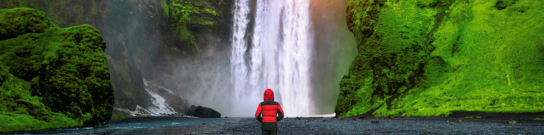
Distance: 7-8 kms Time Taken: 7 hours trek The actual trek starts today. You will slowly move towards the upper reaches of the mountains. We will try to leave right after breakfast because it is likely to be a long day. There is a height gain of 900M and the weight on your back does not make it easy. You start by crossing over the other side of the river through a sturdy bridge with a deep gorge and river underneath. This leads you to the last village you will visit before heading out of the boundary of civilization. The route to basecamp takes you through small villages rich with lush green fields bordered with pink flowers and locals running up and down the steep slopes like it were an Olympic field. Cattle scattered around the landscape, you soon leave the geometric greens behind at the foothills of the mountain and enter the world of browns on narrow shepherd trails– rocks, boulders and mud – extremely dry but rich in flowers of all colors growing out in tufts from the cracks between the land. The mountains here are peculiar – rocky with pointed peaks – completely brown and dry from a specific point upward with lush green fields at the foot of the slopes. You walk through boulders and scree on the many shepherd trails crisscrossed across the landscape dividing the dry greens into mounds of tufts. Three hours into the climb, you reach the pass. The landscape on the other side changes completely, and so does the air. After the steep ascend to get to the pass, you descend down into a much chillier valley – a bit more rustic than the one you left behind. On crossing miles of moraine and glaciers, you will make it to the bottom of the waterfalls. This last leg of the climb is steep (close to a 60 degree gradient) and slippery, thanks to the loose rocks and scree. The basecamp rests waiting for us at the top of the waterfall. Your last challenge is crossing streams of water from the waterfall to get to the warmth of your tents which will be your homes for the next few days to come.
The day starts with a puja. The base camp for Mt. Nun, as of any other mountain, is rife with colour from the prayer flags and small stone structures where you offer your prayers to the mountain gods and thank them for allowing you to be there. This sacred ritual where the team members, seek blessings for the safety and the success of the team ends with a sip of some brandy and some sweets to fill you with warmth along with the benedictions of the mountain. It does help connect you to the mountain better and makes you feel belonged – like your presence is not a burden to the massif anymore. A lot is to be achieved during your time at base camp. From the distribution and setting up of all the gear to technical training and practice on the icy slopes around the basecamp. But before then, you have the entire day to rest your bodies and acclimatise to the terrain, altitude and temperature of the base camp which lay at 4600M – a height gain of approximately 800M from Tangol.
Once you step in to mountaineering, the conditions on high-altitude become unpredictable. There is a constant readjustment of plans to adapt to the situation at the time. Providing fixed day-wise schedules, like we do for treks, is tricky. But roughly, the schedule includes rotation rounds between camps which are a standard acclimatisation process on high-altitude expeditions. Mt. Nun has 3 camps at 5,550M, 6,100M and 6,400M above the basecamp. Camp 1 (5,500M): Camp 1 is at an altitude of 5500M which is a 900M vertical height gain from the Base Camp. The first stretch of this trail includes climbing two hours of a steep rocky slope after crossing the river over to the other side of the camps. This stretch is full of boulders and rocks but has a pretty well laid out trail which makes the ascent a little less grim. The two-hour climb takes you up the mountain ridge and down to the other side requiring you to walk on massive boulders – a stretch to be cautious on till you make it to something called a ‘Crampon Point’. This infamous point is an enormous rock with a little opening at the bottom, making it a perfect place to store all our equipment to protect it from the rain and from being blown away by angry winds. Consider it the green room for your trek – this is where you put all your gear on and get ready for the actual climb. The most difficult section between Base Camp and Camp 1 is the 300M of a 75 degree gradient ice wall. After the first wall, there is an additional patch of steep ice which needs to be navigated. Once we cross the ice wall and its annex, the slopes get a bit gentler and the snow gets a little softer. You then turn to the right, jump over a few crevasses and reach the point where the slope is now at close to 30 degrees. This is the end of the fixed rope section and the start of the land of hidden crevasses. Camp 1 is bang in the middle of a 4kms wide snowfield. Walking the long flat land after a while starts to feel like walking into nothingness. You should reach your tents within 5-6 hours of leaving from Base Camp. Camp 2 (6,100M): The path between Camp 1 and Camp 2 is a straight ascent, through and through, with slopes between 60-70 degrees. The entire stretch of the climb, which is a height gain of 600M from Camp 1, is likely to take an average of 9 hours for the climbers to cover. For the most part of the climb, depending on the texture of the snow, you will find yourself on front point! The most difficult part of the climb, however, remains navigating large sections of boulders and rocks with crampons on. All these conditions aside, Camp 2 is absolutely mesmerising. Mt. Nun, no doubt, has some of the most beautiful and the most thrilling high-altitude campsites. But of the three, Camp 2 is a class apart. It gives you the drama of a 007 film while creating the humour of a Black Jack movie. Resting precariously on a sloped and narrow ridge of a high pinnacle, tents on Camp 2 are literally dangling in the air. With an impossible slope on one side and a direct 800M drop on the other, even to answer nature's call, you have to anchor yourself to the rope. However, whoever dares to look up could vouch for the fact that the campsite gave them some of the best morning and evening views they have ever witnessed. With the rest of the world hidden below clouds and a crack in the sky that added the orange to the otherwise white landscape is nothing short of magical. The sunlight on Mt. Nun from Camp 2, gives it a God-like halo captivating you further. Camp 2 gives you such spectacular sights that the drama and thrill might just be bigger than the summit itself. The cloud show is amazing sitting at that height with an unobstructed view of the snowfield below. The dance of shadows of the clouds on the massive snow field is one show you definitely want front row seats to! Camp 3 (6,400M): Camp 3, which is the Summit Camp, is at an altitude of 6400M which is a 300M vertical height gain from Camp 2. However, it is likely to feel not too taxing after having endured the daunting slopes to reach Camp 2. After the initial steep descent from the campsite, the rest of the route is mostly snow dunes which go up and down at a gradient of not more than 40 degrees. Much like Camp 1, Camp 3 is also stationed in the middle of a snowfield. Camp 2 to Camp 3 should take you close to 6 hours to cover. Summit Push (7,135M): Like all other summits, it is vital to cover as much distance as possible through the night because that’s when the ice is most stable. You start the climb between 11 and 12 in the night. Hopefully all the anxiety and tension from all the physical and mental stress you put your body through the past few days, will dissolve into the calm of the night as you focus on the climb and the goal ahead. You will access the west ridge from Summit camp, which involves traversing on 40-60 degree ice after which the gradient comes down to 40-50 degrees. The last section with large boulders is especially tricky because of the crampons. It is exceptionally hard to carry your weight and pull yourself over the massive boulders after the extreme physical and mental fatigue from hours of ascent. Once the boulders are crossed, however, there is only around 50M more to get to the summit. Expect this round trip from Summit Camp to Summit Camp to take anywhere between 14-16 hours. Camp 3 to Base Camp: This is going to be long day. Be prepared for very steep descends early in the morning– after breakfast. Descends can be precarious so try to keep yourself as focused as while going up the mountain – depleted energy has a way of defocusing your mind. Expect this ordeal to take anywhere between 8 to 10 hours to complete.
After resting your body, pack up your temporary homes on Base Camp and head on down towards Tangol. It is a relatively easy stretch and should take close to 4 hours to cover. We get into our vehicle soon after and make our way down to Kargil.
Distance: 217 kms Time Taken: 6-7 hour drive We will drive towards Leh after breakfast and will reach by evening. Today will be the celebration day after culmination of the expedition.
Your expedition ends here but not before some celebration. How can we end this adventure without a summit party? Like we indicated before, the weather on high-altitude is unpredictable as are many other conditions. So, we would suggest you keep spare days between the end of the expedition and your travel arrangements to head back home.
Plan ahead and lock in your perfect getaway today. Early booking ensures peace of mind, better deals, and a smooth travel experience from start to finish!
To receive our best monthly deals


Him Exped inspires unforgettable journeys, weaving adventure, culture, and Himalayan beauty into every traveler’s story.