
To More Inquiry

Grade:Moderate Location: Himachal Altitude:4632 m Duration:7 Days Spanning over 65 kilometers across the states of Uttarakhand and Himachal Pradesh, Rupin Pass stands out as one of India’s most spectacular cross-over treks. Every twist and turn on the route feels like a grand curtain being drawn back, unveiling awe-inspiring scenery painted in an astonishing palette of colors that will leave you speechless. Whether you're trekking through dense pine and rhododendron forests, passing through a hanging village, navigating vast glacial valleys, climbing the steep and narrow Rupin Pass gully, sliding down snowy chutes to Ronti Gad, or reaching the top of a cascading waterfall—excitement and wonder are constant companions on this trail. Reaching an altitude of 4,650 meters, the Rupin Pass trek is considered moderately challenging—ideal for those who have completed an easier trek and are ready to take things up a notch. While the daily distances are manageable and the elevation gain is gradual, the trail does come with its own set of challenges, requiring a specific set of skills to tackle its varied and demanding terrain effectively. It’s not just the landscape that goes through a series of dramatic transformations—the Rupin River itself takes on many forms as you journey from one campsite to the next. If we had to choose, this would likely be our favorite aspect of the trek. What sets it apart is the rare opportunity to follow the river’s journey so closely—from walking along its bed in Dhaula to reaching the very top of the majestic Rupin Waterfall. Few treks offer such an intimate and evolving connection with a river’s path as the Rupin Pass does. The ideal time to undertake the Rupin Pass Trek is between May to June and September to October. This page serves as your comprehensive guide to the Rupin Pass Trek, covering everything you need—from the detailed route map, weather and temperature insights, to the full itinerary, photos, and videos. Be sure to scroll down to the bottom for firsthand experiences and stories in the Rupin Pass Trek blogs.
Distance: 198 kms Duration: 9-10 hours If you have signed up with HIM EXPED for a drive from Shimla to Jiskun, the day starts early. Everyone assembles at the meeting point by 7 in the morning so we can start our long drive up to Jiskun – a charming agricultural village in the Shimla district of Himachal Pradesh. Although there’s nothing more on the agenda for today other than the 10-hour drive, it is better to leave as early as possible for two reasons: One, so we can reach as early as possible and give our bodies enough rest for what’s coming the next day. And, two, roads on the mountains are unpredictable and it is always better to account for delays when we start. It is also better to reach before it gets dark.
Distance: 6-7 kms Duration: 4-5 hours The trail for today snakes up in a continuous ascent through dense forests after passing through the traditional high-altitude villages of Himachal Pradesh. Once we cross the last signs of habitation, we cross over a small wooden bridge and head on upwards towards our destination for today.
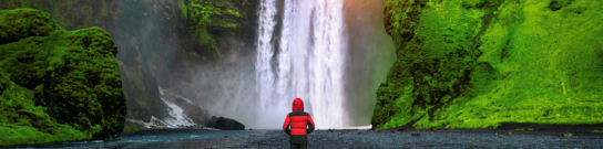
Distance: 11-12 kms Duration: 8-9 hours Today’s trail takes us all the way down to the river to walk alongside its beautiful blue waters as we follow all its curves and bends. The thicket of fir forests quickly transforms to patches of snow. On crossing these, a snow bridge and a wooden bridge, we hop and jump over some boulders and streams to enter another magical forest – this one rich in rhododendrons of varied hues. A few more kilometers and we reach Saruwas Thatch– a massive field of meadows rich in all kinds of fresh colours. A little rest here and we push on towards Dhanderas Thatch which s only a short distance from here. Don’t mistake short for unexciting, however because this might as well be the best day of the entire trek which offers some of the most beautiful landscapes. This short walk on the colourful meadows takes us straight to the foot of the roaring Rupin waterfall which doubles up as our campsite for today. The magnificence of this trek is the constantly changing scenery – while the first day took us through fir forests, the second through rhododendrons, today we walk through the luminescence of silver oak trees until we end up at the campsite for the day – Dhanderas Thatch.
This day can be used as a rest or buffer based upon the weather conditions and participants fitness. This day can be used at any camp and is at the discretion of the Trek Leader.
Distance: 4 kms Duration: 3 hours Today’s trek is relatively short but exciting! We will be making our way to the top of the Rupin Waterfall. This section is important because it gives you ample time to acclimatize to the changing altitude and prepare for what is to come next. The morning begins at leisure allowing the trekkers to rest their limbs properly. For about 1 km, the trail is fairly level as you cross several streams on your way decorated with a display of wild flowers and marigolds. The next section is tricky as you reach the snow patches at the base of the waterfall. This is when your snow equipments like trekking pole and ice-axe would come into play. The trek on snow is particularly challenging as the trail is steep and narrow in many sections. This continues for the next 1.5 kms before you reach the meadow at the top. The Upper Waterfall Camp is a gorgeous meadow on the banks of a gently flowing stream. You will get to see the spectacular mountain ranges covered in snow and several streams running down through them merging into the Rupin river and disappearing below your feet. While everyone has seen a waterfall closely, only a few can claim to have seen it right from the top and observe it fall down right into the valley. You will one of those lucky few. Capture this moment at the most cinematic location one can imagine. This campsite is a true sight to behold!
Distance: 4 kms + 4 kms Duration: 6-7 hours + 2-3 hours This is perhaps the longest and the most thrilling day of the trek. We begin as early as 5 AM and carry packed lunch and breakfast along to reenergize ourselves on the way. The challenges begin to appear shortly after we begin the trek. The ascent to Rati Pheri is a steep incline veering through snow and gains a generous amount of altitude in an hour. The trail climbs over a ridge before reaching the campsite of Rati Pheri. The landscape changes beautifully at Rati Pheri – a promise best kept by the Rupin Pass trek! The expansive views of the Rupin valley are replaced by the alpine Dhauladar range as you now move ahead over vast snowfields. Your trek leader will provide you with appropriate snow equipments such as microspikes and gaiters depending upon the level and density of snow on the trail. From Rati Pheri, the trek is steep and quite demanding as the snow makes it difficult to trudge through. It is slipper in some sections, while at others the snow may be knee-deep demanding every ounce of your energy to take that next step. All the snow techniques you have learnt so far are put to test and how so. In about 3.5 hours, you will finally reach the base of the Rupin Pass gully. Take some time to rest and rejuvenate for the gruelling trek ahead. The Rupin Pass gully is a narrow and steep half tube in the mountain side that is prone to lose stones falling over. It stretches over 200 m and would take anywhere between 40 minutes to 1 hour to cover, depending upon the level of snow and the speed of the trekkers. After a long and steep icy-climb, the sight of the saddle shaped Rupin Pass cutting its way through the Dhauladar Ranges rewards you with a feeling of pure bliss and euphoria. Hundreds of stone cairns and colourful prayer flags adorn the ridge line that offers impressive views of the Kinner kailash range in the north and the Rupin valley in the south. Spend some time at the ridge and relish the eternal glory of the spectacle in front of you. The next phase of the trek steps up the fun quotient by a notch or three. To reach the Ronti Gad campsite, you get to glissade down the chutes of snow. The descent is sharp and rapid and sliding down the snow slope is the best way to cover the distance. The slopes even out, after the steep descent, making for an easy walk. Once you cross snowline, be prepared for another sharp descent that leads you to an endless meadow with a stream flowing gently through the mountains. This is the Ronti Gad Campsite. You will be camping here for the night in the vicinity of the towering snow-capped mountains – yet another pleasant change in the landscape around.
Distance: 13 kms + 225 kms Duration: 5-6 hours trek + 7 hours drive We begin the descent to Sangla after breakfast, at around 9 AM. The trail is a dusty shepherd’s path as you move out of the Ronti Gad campsite. You may come across mule traffic and shepherds tending to their cattle along the way. Almost 2 hours into the trek, you will see the Ronti Gad valley retreating slowly behind you and the trail ahead opening up to first glimpses of the snow-clad Kinner Kailash range. The sight is an absolute marvel to behold. Soon afterwards, you will see the first signs of civilization afar in the tiny village of Sangla Kanda. Take a quick break in the Sangla Kanda village and have a hot cup of tea to give yourself some respite from the sharp descent. The trail from Sangla Kanda to Sangla veers through blue pine forests that come as a refreshing surprise. The trek gradient is a rapid decline over a broad well-defined path going through terraced farms, apple orchards and old stone houses. As you finally reach Sangla, take one last look at the giant mountains around and bid adieu to one of the finest cross-over treks of the country. *We will reach Shimla late at night, so make your hotel reservations accordingly.
Plan ahead and lock in your perfect getaway today. Early booking ensures peace of mind, better deals, and a smooth travel experience from start to finish!
To receive our best monthly deals


Him Exped inspires unforgettable journeys, weaving adventure, culture, and Himalayan beauty into every traveler’s story.